


What is the OGC’s role in Energy and Utilities?
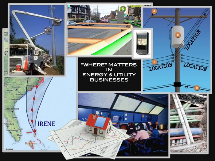
Every energy and utility businesses’ asset and customer has a location, and their locations matter. Distance matters. Proximity matters. Depth and elevation, transmission speed, line losses, customer engagement demographics, slope, land cover, anticipated damage, siting costs, rights of way – These are all location information. You can potentially manage what you can observe, but only if you can communicate the location components of the raw data, the processed data, and the decisions about assets and customers.
Communication about location is essential in everything from oil and gas exploration to wind farm siting, municipal energy conservation and maintenance of pipes and wire lines. Location communication becomes even more essential with the rapid rise in the sources, uses and requirements for location information. Every line crew and most customers have digital mobile devices that can report location. Sensors to measure a wide range of phenomena are going wireless, demanding very little power and becoming smaller and less expensive – and they can often report their location, which usually matters. Customers’ increasing service demands and the increasing demands imposed by environmental and regulatory agencies further require the use of timely and accurate location information.
As everything becomes more connected and measured and as Information Technology (IT) advances, analytics and decision support systems potentially make possible provision of cleaner and more secure energy, power and water. Supply can be more precisely matched to users needs, at lower cost to users. However, this progress assumes that major market players will put in place the necessary modern information infrastructure.
Today, digital communication almost always means communication via the Internet and the Web, and such communication usually involves service provision. When you enter an address into a map browser, or make a purchase on a website, or use the Web to check your gas bill, you are using a Web service, or more likely, a chain of Web services that communicate in an ad hoc fashion through open interfaces. Web services depend on internet standards like HTTP and Web standards like HTML. Spatial Web services depend on standards from the OGC and ISO.
OGC Web Service and related encoding (content) standards are becoming established in a range of information domains such as aviation, weather, hydrology, defense and intelligence, earth observation, and emergency and disaster management. The use of OGC standards is not yet well established in the energy and utilities domain. A new research study from Newton-Evans reports that two-thirds of European utilities have adopted a service-oriented architecture (SOA), while only one-fifth of North American utilities have done so. What precedes SOA in the energy and utilities domain is isolated utility geographic information systems (GIS), isolated customer relationship management (CRM) systems and isolated Supervisory Control And Data Acquisition (SCADA) systems and the limitations imposed by their isolation.
Utility GIS systems need to talk to SCADA systems. Emergency response systems need to talk to utility GIS systems. Field crew operations systems need to talk to customers’ Building Information Models. A regulator’s system needs to talk to the GIS systems of multiple utilities. A utility CRM system needs to talk to a map browser. An asset planning application needs to talk to a state or federal data server that provides land cover data or weather statistics. All of this communication should happen with a few mouse clicks and key strokes, or with no user intervention, as workflows increasingly depend on chained services.
The OGC facilitates a process in which organizations work together to create international standards that they can use to get their systems to “speak the same language” when communicating location or more complex geoprocessing service requests. Many of the necessary standards are already available, but others are not. Organizations bring their industries’ interoperability requirements into the OGC, learn what has been done and what needs to be done, and then work out the bits and bytes of standards and best practices including harmonization with standards from other standards development organizations (SDOs). The OGC educates developers and system architects and helps promote the new standards and best practices. Implementation and deployment follow, and the Internet moves closer to being a system of systems that can readily share all types of spatial data and processing.
What has the OGC done so far?
The OGC was founded in 1994 to deal with geospatial data sharing issues. The goal soon evolved into providing a consensus process in which members could develop open interface standards that enable different vendors’ GIS systems to exchange requests and responses. Virtually all GIS vendors now implement basic OGC standards such as the OGC Web Map Service Interface Standard and the OGC KML Standard for map browsers.
The OGC Energy & Utilities Domain Working Group (E&U DWG) was chartered in 2012 to begin looking at geospatial standards related to the Smart Grid. National and international Smart Grid standards efforts have largely ignored the requirement for diverse systems to communicate location information and geospatial service requests and responses. The OGC E&U DWG has a mandate to look at individual use cases, introduce these into the scenarios of testbeds, pilot projects and interoperability experiments, and work with the OGC Technical Committee and with other SDOs to resolve geospatial interoperability issues.
An important electric power industry standard for the Smart Grid is the Common Information Model (CIM), developed by the electric power industry and officially adopted by the International Electrotechnical Commission (IEC), which is the main SDO for the Electric Industry. CIM enables application software to exchange information about the configuration and status of an electrical network. This supports the organization’s overall goals of fostering enhanced functionality, lowering integration costs and increasing the rate of market adoption of Advanced Metering networks and Demand Response solutions through the development of open standards and interoperability guidelines. CIM is now harmonized with WXXM (Weather Information Exchange Model), which is an industry profile based on GML. More work remains, however, before the CIM will be spatially enabled to the degree that the Smart Grid requires.
The OGC played a role in organizing a special Open Smart Grid User Group (OSGug) Technical Subcommittee session, initiated by Margaret Goodrich of SISCO and Frank Wilhoit of American Electric Power. At this meeting the Open Smart Grid group agreed to establish a geospatial task force focused on identifying requirements and moving forward on further efforts to harmonize the geospatial aspects of the Common Information Model (CIM).
The Smart Grid involves many other standards, however, and much more standards coordination and development will be required to enable efficient geospatial communication within smart grids and between smart grids and neighboring activities such as emergency response, disaster management, urban planning and building energy management. For example, while CIM is used by most investor-owned utilities (IOUs), in North America a similar standard, MultiSpeak, is used by most electric co-ops and municipally-owned electric utilities.
INSPIRE (Infrastructure for Spatial Information in the European Community), is an important program for geospatial standards coordination in Europe. One point of interest to the wider energy industry addressed by the E&U DWG is that INSPIRE partners are engaged in the creation of an abstract application schema for smart grids that will apply to all utility networks, including not only electricity but also water, sewer, thermal (as in district heating), and oil, gas & chemicals pipeline networks. Europe has a strong interest in the Energy Community of Practice of the Global Earth Observation System of Systems (GEOSS), a project of the international Group on Earth Observation (GEO). The GEOSS Architecture Implementation Pilot (AIP), begun in 2006, is led by the OGC.
QUEST is a collaborative network of stakeholders who work to design, develop and apply Integrated Community Energy Solutions (ICES) in Canada. Integrated Community Energy Maps (ICEMs) and associated community initiatives are already contributing meaningfully to community energy and emissions planning in Canada. For example, the Canadian Urban Institute (CUI) initiated the Integrated Energy Mapping for Ontario Communities (IEMOC) project with the Cities of Guelph, Hamilton, London, and Barrie Ontario. Integrated energy mapping strategies were applied and further developed, including in the transportation domain. Maps were produced illustrating baseline and projected energy use and GHG emissions under business as usual, high and ultra high efficiency scenarios. Capital and operating costs were calculated for each building efficiency strategy and alternative energy generation technology. Simple payback, Internal Rate of Return (IRR) and dollars per tonne of GHG reduction ($/tonne) enabled stakeholders to evaluate the cost-effectiveness for energy and GHG reductions (Gilmour, Margerm, Warren, 2010).
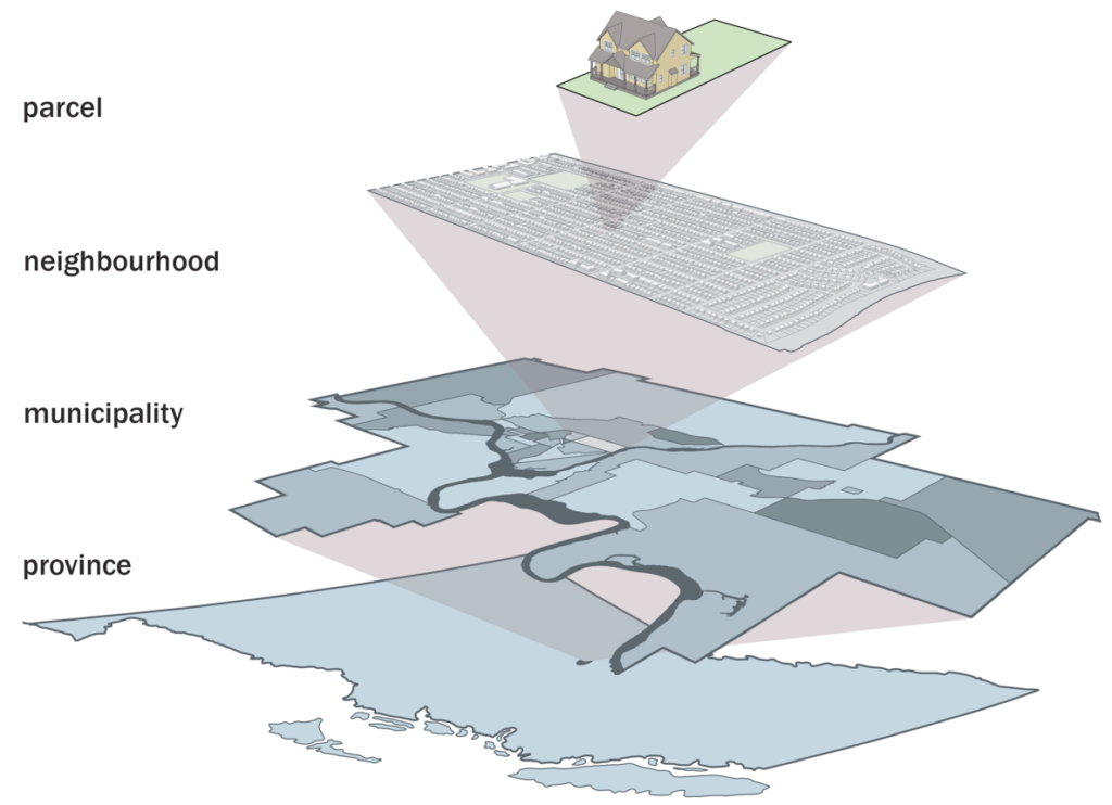
Figure: Graphic from Tract and Neighborhood Data Modeling project 2012, Government of British Columbia, depicting Community Energy and Emissions Inventorying. Emissions can be calculated and mapped from parcels’ energy profiles.
The growing use of mapping to support energy decision-making, among both communities and utilities, underscores the need for web-based communication of geospatial data and for interoperable geospatial processing queries and responses. ICES require the construction of a “nervous system” that connects the diverse set of parties involved in energy decision-making. QUEST is working with OGC to determine industry interest in a testbed to advance the concept of an “Energy Spatial Data Infrastructure” (Energy SDI) that would inform ICES planning and management.
The OGC’s Energy & Utilities Alliance Partnerships
The OGC maintains alliance partnerships with many standards development organizations (SDOs) and industry associations to ensure that OGC standards work well with other standards and to ensure that OGC standards meet user requirements across a broad spectrum of domains and applications. OGC Alliance Partners whose work relates to Energy & Utilities include: US National Institute for Building Standards (NIBS), Electronic Commerce Code Management Association (ECCMA), Web3D Consortium, Organization for Advancement of Structured Information Standards (OASIS), Sensors Anywhere Consortium (SANY), World Wide Web Consortium (W3C), CEN 287 – Geographic Information, IEEE Technical Committee 9 (Sensor Web), ISO Technical Committee 204 – Intelligent transport systems, ISO Technical Committee 211 (ISO TC/211) – Geographic information/Geomatics, the PODS Association, and the Open Mobile Alliance (OMA).
As a result of this cooperation, the OGC Geography Markup Language (GML) Encoding Standard has been incorporated into a wide range of standards that play important roles in domains such as emergency management, Location Based Services, weather, air traffic management, Internet device location and the Semantic Web.
Alliance partnership memoranda of understanding (MOUs) are not sufficient in themselves. The OGC does not have staff to participate regularly in the working groups of these other SDOs. We depend on our member organizations to provide cross-SDO collaboration.
Participate!
The strategic agendas of technology users and technology providers in the OGC drive progress toward location interoperability and technology convergence. Different communities of practice and communities of interest have different needs and agendas, but often these communities’ needs and agendas overlap. Participating in OGC activities facilitates multi-community and cross-domain cooperation and cost sharing.
For sound business reasons, hundreds of public sector, private sector and academic organizations from countries around the world have dedicated resources since 1994 to create open standards in the OGC. Their representatives’ work and OGC’s cooperation with other standards organizations have enabled much of the location interoperability that we take for granted.
OGC membership provides a cost-effective way for technology users and providers to influence and track the progress toward 21st century “ubiquitous computing” that connects the digital world to the real world.
The OGC members have evolved a process and policies and procedures for standards development that are somewhat unique in the standards world. Most requirements gathering and standards development takes place in the OGC’s rapid prototyping testbeds and interoperability experiments. These activities produce Engineering Reports that provide content for candidate standards that are brought into the working groups of the OGC Technical Committee for finalization, vetting and voting. Companies and organizations in the Energy and Utilities world are invited to bring their interoperability requirements into this process.
See the OGC’s Requests Page for information about interoperability initiatives for which the OGC seeks quotations and participation. Subscribe to the Distribution List to learn about new requests and to receive comments as they are submitted.
We encourage you to visit http://www.opengeospatial.org/contact to learn how participation in the OGC can help your organization achieve its objectives.
Contact: http://www.opengeospatial.org/contact.
We represent over 500 businesses, government agencies, research organizations, and universities united with a desire to make location information FAIR – Findable, Accessible, Interoperable, and Reusable.


Receive the latest news on OGC.
© 2024 Open Geospatial Consortium. All Rights Reserved.